About Sabah/Sabahan

About Sabah: A little bit you need to know about Sabah


Why You Must Visit Sabah, Borneo of Malaysia.........


Sabah  The Land Below the Wind.


SABAH Known as ‘The Land Below the Wind’ because geographically, it is below the typhoon belt, Sabah sits at the northern tip of Borneo. It has one of the world's greatest treasures of rainforests and wildlife. Mount Kinabalu, South East Asia's highest mountain, is found in Kinabalu Park. Excellent dive sites are available at Sipadan Island and at the Layang-Layang atoll.
Sabah's colourful people comprise 31 different indigenous groups and unique cultures.


For the main attractions are its outstanding national parks, which include Kinabalu National Park, the Crocker Range Park, and the Sepilok Orang Utan Sanctuary. Others come to enjoy the islands of Tunku Abdul Rahman National Park and the diver's paradise of Pulau Sipadan. However, Sabah possesses a number of other attractions as well, all of which are worth exploring.
International access is through Sabah's capital, Kota Kinabalu. Domestic travel in this vast state is via daily domestic flights to the various towns with and out of the state.
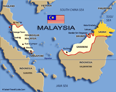


Map Of Sabah.


Situated on the beautiful island of Borneo, Sabah is one of the thirteen states which Malaysia is made of. Sabah is the second largest state in Malaysia and shares the island of Borneo with Sarawak, Brunei, and Indonesian Kalimantan.Ideal for backpackers, Sabah is richly blessed with nature diversity, unique cultures, fun adventure, beautiful beaches, and fantastic cuisines for the adventurous taste buds. We have it all, from the world’s largest flower – the Rafflesia, one of the highest mountains is South East Asia – Mount Kinabalu, to one of the world’s top dive sites – Sipadan Island.Not only will you be amazed by the places to see and things to do here, you will also be treated with unique Sabahan hospitality. Explore the unique culture and tradition of Sabah and get ready to experience sweet memories to last a lifetime!The people of Sabah are known as Sabahans. Sabah is the third most populous state in Malaysia after Selangor and Johor; it also has one of the highest population growth rates in the country.There are currently 32 officially recognized ethnic groups in Sabah with the largest non-indigenous ethnic group being the Chinese and the largest indigenous group being the Kadazan-Dusun people. Two other larger ethnic groups in Sabah are the Bajau and Murut, compared to other states in the country; Sabah has relatively very small population of Indians and South Asians.Apart from the Sabahans’ very own diverse mother tongues, Bahasa Malaysia (national language) and English is widely spoken; Mandarin and some Chinese dialects are also widely spoken.


About Sabahan


The people of Sabah are divided into 32 officially recognised ethnic groups. The largest non-bumiputra ethnic group is the Chinese (13.2%). The predominant Chinese dialect group in Sabah is Hakka, followed by Cantonese and Hokkien. Most Chinese people in Sabah are concentrated in the major cities and towns, namely Kota Kinabalu, Sandakan and Tawau. The largest indigenous ethnic group is Kadazan-Dusun, followed by Bajau, and Murut. There is a much smaller proportion of Indians and other South Asians in Sabah compared to other parts of Malaysia. Cocos people is a minority ethnic residing in Sabah especially at the Tawau Division. Collectively, all persons coming from Sabah are known as Sabahans and identify themselves as such.
Sabah demography consists of many ethnic groups, for example:KadazanDusun,Malay,Kwijau,Murut,Bajau,Illanun,Lotud,Rungus,Tambanuo,Dumpas,Mangka’ak,Suluk,Orang Sungai,Melayu Brunei,Kedayan,Bisaya,Tidong,Maragang,Orang Cocos,Paitan,Ida’an,Minokok,Rumanau.Sabah born Chinese (Malaysian),Sabah born Chinese with mixed indigenous parentage Example: Bumiputra Sino Kadazan etc.,Lundayeh,Other inhabitants:Filipino – Chavacano,Visaya,Ilocano,Suluk,Badjao,Iranun,TausugIndonesian – Bugis,Jawa,Timoris,BanjarIndian – Punjabi,TamilSarawakian indigenous – Iban,Penan,Dayakreference wikipedia


Sabah Welcome You
Where To Visit In Sabah.

Sabah Place of Interest.


http://www.sabahtravelguide.com/images/index_page/SABAH-MAP.jpg


Chinese Version


English Version


http://www.sabahtravelguide.com/mapguide/default.asp?page=hotsprings


WELCOME TO:Borneo Holidays, Sabah Tourism & Sabah Sipadan Island Travel Guide


Kota Kinabalu City 12 Years Before/Ago!!


Kota Kinabalu Year 1996.


Kota Kinabalu Year 1996 In Color.


(This photo is a Copyright©1996 by/belong to Tommy Chang and scanned from one of his photography book call SABAH Malaysian Borneo, People & Places, published by Tommy Chang Image Production Sdn Bhd.)


This how Kota Kinabalu city looks like from a bird’s eye view back in the year 1996.


[Eng] About Kota Kinabalu

Kota Kinabalu (pronounced [ˈkɔtɑ kɪnɑbɑlʊ]), formerly Jesselton, is the capital of Sabah state in Malaysia. It is also the capital of the West Coast Division of Sabah. The city is located on the northwest coast of Borneo facing the South China Sea. The Tunku Abdul Rahman National Park lies on one side and Mount Kinabalu, which gave the city its name, is nearby. Kota Kinabalu proper has a population of 543,765, while the larger urban area has an estimated population of 700,000. It is the largest urban centre in Sabah and the sixth largest in Malaysia.


Kota Kinabalu is often known as K.K. within Malaysia and internationally. It is a major tourist destination and a popular gateway for travellers visiting Sabah and Borneo.[2] Kinabalu National Park is located about 90 kilometres from the city and there are many tourist attractions in and around the city. Kota Kinabalu is also one of the major industrial and commercial centres of East Malaysia. These two factors combine to make Kota Kinabalu one of the fastest growing cities in Malaysia.


KOTA KINABALU (IBU NEGERI SABAH)


Kota Kinabalu (atau "KK") ialah ibu negeri Sabah, Malaysia. Nama bandar ini diambil sempena nama gunung yang tertinggi di Sabah dan juga tertinggi di Asia Tenggara, iaitu Gunung Kinabalu. Terletak di Bahagian Pantai Barat Sabah, ia merupakan pusat perdagangan dan industri yang utama di negeri Sabah. Kota Kinabalu mencapai taraf bandar raya pada 2 Februari 2000.

Kota Kinabalu berada pada latitud 5.983° dan longitud 116.067°. Sehingga banci pada tahun 2000, jumlah penduduknya ialah 354,153 orang, dengan populasi metropolitan seramai 900,000 orang.


Sejarah:

Semasa pemerintahan British di negeri Sabah (dikenali sebagai "British North Borneo" pada waktu itu), pusat pemerintahannya Pulau Gaya. Satu peristiwa kebakaran telah melanda Pulau Gaya dan pihak British terpaksa mengalihkan pusat pemerintahan ke sebuah perkampungan nelayan di persisiran Pantai Barat Sabah yang dipanggil "Gentisan". Petempatan tersebut bertukar nama kepada "Jesselton" sempena memperingati Sir Charles Jessel. Apabila Sandakan, yang pada waktu itu merupakan ibu negeri "British North Borneo", musnah teruk dalam Perang Dunia Kedua, pentadbiran British telah dipindahkan ke Jesselton.

Jesselton kemudiannya bertukar nama kepada "Kota Kinabalu" pada tahun 1967, iaitu 4 tahun selepas Sabah menyertai gagasan Malaysia yang baru. Bandar raya ini telah melihat perkembangan yang pesat sekali pada tahun 1970-an dan 1990-an. Beberapa pekan yang baru telah muncul akibat daripada pembukaan paya bakau dan hutan belantara. Kota Kinabalu diisytiharkan menjadi bandar raya Malaysia yang pertama di alaf baru pada 2 Februari 2000. Datuk Ghani Rashid adalah Datuk Bandar Kota Kinabalu yang pertama. Datuk Iliyas Ibrahim dilantik sebagai Datuk Bandar kedua pada 2 Februari 2006, sempena ulangtahun keenam pengisytiharan Bandaraya ini, dan masih memegang jawatan tersebut sehingga hari ini.


History

In the late 1800s, the British North Borneo Company (BNBC) began to establish colonies throughout North Borneo (now Sabah). In 1882, the Company founded a small settlement on Gaya Island (Pulau Gaya), which was already inhabited by the Bajau people. In 1897, this first settlement was burned and destroyed by Bajau rebels led by Mat Salleh.

After the rebellion, the Company decided to relocate the settlement to the more easily defended mainland opposite Pulau Gaya. A nearby fishing village named Api-Api (see Original names below), was the next settlement of the Company. This new location was then designated as the main harbour and port, as well as the terminus for the North Borneo Railway. It was expanded and renamed Jesselton, named after Sir Charles Jessel, the then Vice Chairman of the Company.

Eventually, Jesselton became a major trading post of North Borneo, dealing in rubber, rattan, honey, and wax. The new railway was used to transport goods to Jesselton harbour. Bajau uprisings during these times were not uncommon, and the Company worked to quell the long-standing threat of piracy in the region.

A bird's eye view of Kota Kinabalu from Penampang.Jesselton was razed by the retreating British early in World War II to prevent it from falling into the hands of the Japanese. After the Japanese takeover of Borneo, it was again renamed Api. Rebellions against the Japanese military administration have taken place in Api. One major rebellion occurred in 1943 by the group called Kinabalu Guerrillas, consisting of local inhabitants. The rebellion was however quelled by the Japanese forces, after their leader, Albert Kwok, was arrested and executed in 1944. At the later stages of the war, what remained of the town was destroyed again by Allied bombings as part of the Borneo Campaign in 1945, leaving only three buildings standing. The war in North Borneo ended with the official surrender of the Japanese 37th Army by Lieutenant General Baba Masao in Labuan on September 10, 1945.

After the war, the British North Borneo Company returned to administer Jesselton but was unable to finance the huge costs of reconstruction. They gave control of North Borneo to the British Crown in 1946. The new colonial government elected to rebuild Jesselton as the capital of North Borneo instead of Sandakan, which had also been destroyed by the war.

When North Borneo together with Sarawak, Singapore & Federation of Malaya formed the Federation of Malaysia in 1963, the state became known as Sabah and Jesselton remained its capital. Jesselton was renamed Kota Kinabalu on September 30, 1968 and received official city status from the Malaysian government on February 2, 2000.


No comments:

Post a Comment